Friday, December 5, 2014

Advancing UNIGIS Latin America

The past months marked an intensive period of outreach activities carried out by the UNIGIS program established at the University San Francisco de Quito (USFQ) and several partner universities in Latin America. For the first time, the annual UNIGIS-symposium ForoMundoUNIGIS was not only held at USFQ, Ecuador and ICESI, Cali but also at our new partner sites at University Belgrano (UB), Argentina, Universidade do Estado do Rio de Janeiro (UERJ), Brasil and the National University Federico Villareal (UNFV), Perú. These events were addressed especially to the growing community of UNIGIS students and alumni in these countries aiming at giving them a platform for presenting their thesis and professional projects as well as building sustainable personal and institutional networks.


The third anniversary of the ForoMundoUNIGIS at USFQ, taking place on October 22/23, gave reason for the UNGIS Team Latin America and the associated colleagues from our regional study sites to gather in an 10-days work shop where internal procedures were discussed and refined in order to providing a high-quality service to all of our students in the future.

Thursday, November 27, 2014

UNIGIS at Asia Geospatial Forum' 2014 Jakarta


UNIGIS was invited to contribute to the Asia Geospatial Forum 2014 (AGF) held in Jakarta, Indonesia from 25th to 27th November, 2014 and to conduct the 'GeoCapacity Forum' - bringing together academia, industry, organisations and students on a common education-oriented platform for face-to-face interaction. The AGF is one of the biggest regional conferences focussed on Geospatial themes in S/E Asia and has been organised in a different country every year since 2003. UNIGIS has been entrusted with a prominent role of conducting Geospatial Capacity Building sessions at the event since 2005.

Dr. Shahnawaz (Director, UNIGIS S/E Asia) represented UNIGIS and gave the lead presentation setting-up the overall framework as well as moderating the forum involving about 30 participants from Indonesia, Iran, Korea, Malaysia, Philippines and Thailand. The first session was dedicated to presentations from students, organisations and industry followed by a second session devoted to plenary discussion.

The forum concluded with a vibrant open-floor discussion where a majority of students expressed that most of the educational institutions in the region offer geospatial study programmes at undergraduate levels and the GIS skills attained at this level are not sufficient to secure them good jobs. On the other side, the representatives of organisations and industry expressed that they are not finding the 'ready-to-deliver' job-seekers, which is hampering the growth of geospatial projects in the affected  regions.

Two distinguished panalists, Prof. Mastura Mahmud (Deputy Dean of Research, National University of Malaysia) and Dr. Chawee Busayat (Director of ITarch, Thammasat University, Thailand) exchanged their experiences about Geospatial Education in the SE Asia region as well as their visionary ideas for expanding it across the ASEAN space and enhancing its status to meet the challenges of the Job market. They also suggested that universities should offer geospatial education as a blend of online distance learning and classroom based residential periods. This will help not only current students, but also shall provide opportunities for in-service professionals to enhance their competences.

The attendees largely agreed that there is a need of exploring alternative modes of delivering geospatial education in the region serving the needs of current students as well as in-service professionals; all agreed that online distance learning programmes will serve these Needs best!


Sunday, October 26, 2014

Winners of the UNIGIS Academic Excellence Prize

The UNIGIS International Association (UIA) is honoured to announce the winners of its 2014 Academic Excellence Prize:

This award, initiated in 2008, is presented to the student, or students, nominated by their UNIGIS sites for submitting the best MSc thesis (or paper) during the academic year. This year the competition was very tight with nine excellent high quality MSc theses being considered by the review panel. In the end the panel decided to make four awards.

The winner of the Academic Excellence Prize for 2014 was Heidi El Hosaini (UNIGIS UK), the first runner up was Trang Minh VoPham (USC) and in joint third place were Cátia Sofia Alves Gouveia (UNIGIS Portugal) and Stefan Mayer (UNIGIS Salzburg). The Review Panel would like to commend and congratulate these individuals and the other candidates for the high quality of work.

Winning thesis topics:
  • Heidi El Hosaini (UNIGIS UK) "Locating and positioning solar panels in a 3D city model – a case study of Newcastle".
  • Trang Minh VoPham (UNIGIS USC) "Integrating Landsat and California Pesticide Exposure estimation at aggregated analysis scales: accuracy assessment of rurality".
  • Cátia Sofia Alves Gouveia (UNIGIS Portugal) "Predicting the impacts of climate change on the distribution and conservation of endemic forest land snails of Madeira Island".
  • Stefan Mayer (UNIGIS Salzburg): "An approach to model the thermal demand of buildings. A case study using two districts of Graz".

Wednesday, October 22, 2014

Start learning the language of space!

No matter if you develop agrarian insurance products, maintain facility networks, provide data for community planning or do research on golden eagles: space matters.

The real world doesn’t happen on a needles tip. It requires physical space. Space not as a kind of arbitrary shoebox, it is the spatial configuration of things that often plays the key role: Real world processes require a certain form of coincidence, adjacency, nearness, connectedness or other form of spatial relationship between their elements to work out fine or happen at all.  Maps can help to understand those processes in their spatial and chronological dimension, computers can be used to model and simulate them in a digital sandbox, representing the real world.

However, before we can do so and use the respective results to make better decisions, we need to learn.  Not just about GI-software and data but also about the language of space. A group of 15 future GI-professionals will extensively do so within a year from now and already made a start at their introductory workshop in Salzburg. The first geospatial insights came cloud-based and shed a light on the spatial properties of the group itself. Who might be easy to reach partners to establish a local learning group? Is it possible to define my spatial neighbors and if yes, who are they? Also the question of centrality was discussed. However, centrality within a student group doing distance learning is probably better expressed in non-spatial terms: Sometimes communication matters as well.

Tuesday, October 14, 2014

Upcoming u_Lecture Webinars

UNIGIS u_Lecture webinars are presented by invited speakers from academia, the GI industry, public administration, NGOs and other actors in the field of Geoinformatics and GIScience. Although this online lecture series is primarily designed for UNIGIS alumni and active UNIGIS students, participation is free for everybody.

u_Lectures autumn/winter:

  • 25 November 2014:
    Darren Ruddell, University of Southern California

    Geospatial Technologies and Urban Resilience: Building a Better World
  • 16 December 2014:
    Muki Haklay, University College London

    What geographic information science got to do with citizen science?
  • 27 January 2015 (double feature, MSc work):
    Heidi El-Hosaini, MSc student @ UNIGIS UK*
    Locating and positioning solar panels in a 3D city model - a case study of Newcastle, UK
    Emma Lewinson, MSc student @ UNIGIS UK*
    Analysing British wildlife distributions using a mobile GIS app for data capture

    *Both students will present an overview of their recent MSc research work at UNIGIS UK.

We cordially invite you to make use of this professional and academic ‚updating‘ opportunity.

Saturday, October 4, 2014

Success story of UNIGIS Hungary continued ...

On September 20th, this year's group of 12 new UNIGIS candidates met for the first time under the new umbrella of Óbuda University. The Institute of Geoinformatics at the Alba Regia Technical Faculty in Székesfehérvár welcomed a highly motivated and ambitious class composed of surveyors, agricultural and forest engineers, geographers and other disciplines.

With this 19th intake UNIGIS Hungary continues to offer advanced education within the UNIGIS International framework, leading students to a formal qualification with a postgraduate certificate and options to obtain international MSc degrees.

Monday, September 22, 2014

UNIGIS Day Switzerland

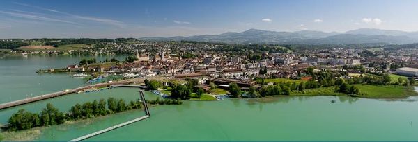
No matter if you listen to experts from the domain of environmental or regional planning, the administration of agricultural subsidies or the simulation and visualization of urban masterplans - GIS plays and will play a significant role. And thus fundamental GIS education is widely demanded. This is the essence of this year's UNIGIS Day Switzerland which took place last Friday (09-19) at the University of Applied Sciences in Rapperswil (HSR).

This is the place to be at UNIGIS Day Switzerland!
Approximately 50 UNIGIS alumni and students, active members of the Swiss GIS community and experts from industry, administration and academia spent the whole day at lake Zurich to gain insights into various fields of GIS application and to exchange experiences and ideas in interactive workshop sessions (slides will be available here).

UNIGIS alumni Andreas Eisenhut gave a presentation about his every day challenges in a planning office. Interestingly, data acquisition and data accessibility are still significant bottle necks; especially in inter-cantonal projects. This is why he plead for more efforts being put into providing harmonized data as web services. Another important hint came from Dr. Keller from the canton of Zurich. He pointed to the fact that agencies which have large monetary turnovers are eager to adopt GI technologies for their systems because a minimum amount of increased efficiency leads to significant cost reductions in absolute numbers. Dr. Keller brought the example from subsidies in agriculture where the canton of Zurich pays an annual amount of 180 mio CHF to farmers. If GIS helps to improve the accuracy of the subsidized areas by only 1% the canton saves 1.8 mio CHF!

Both examples illustrate the potential benefits of a broad implementation of GIS know how which is the perfect argument for UNIGIS' offer of domain-independent, in-service GIS education.
The HS Rapperswill, the exclusive UNIGIS node in Switzerland, is the perfect place to make first steps into advanced GI applications. Courses taken within their post-graduate programs (CAS courses) can be credited for any UNIGIS study (electives). Furthermore HSR serves as first contact point in Switzerland for anyone interested in UNIGIS.

Monday, September 8, 2014

UNIGIS MSc Days in Nepal

UNIGIS@Kathmandu organised a week long intensive workshop from September 1-6, 2014 at Kathmandu Forestry College (KAFCOL), Nepal. The workshop focussed on enhancing the geospatial analytical competences of UNIGIS MSc candidates by critically discussing their Master theses currently being prepared by 9 students. The students presented preliminary findings of their research encompassing a range of topics highly relevant to the environment and society in the Himalayas. 

Their research areas covered land use / land cover changes, forest biomass estimation in various ecological zones, soil carbon estimation, habitat suitability for particular tree and animal species as well as applications of GIS for evaluating municipal tax collection systems and garbage management systems. The presentation sessions were open for participation and critical feedback by other students and faculty members. The vibrant discussion sessions spread over 2 days followed by a thesis proposal session by another 14 students now entering into the MSc thesis stage.


Dr. Shahnawaz (Director, UNIGIS S/E Asia), Dr. Ambika P. Gautam (Principal, KAFCOL), Mr. Durgendra Kayastha (Coordinator, UNIGIS@Kathmandu) and Dr. Krishna Poudel conducted the workshop. The week concluded with a meeting of the Board of Studies to review the progress of UNIGIS@Kathmandu. The Board expressed immense satisfaction with the outcomes and decided to organise such workshops more frequently and, possibly, to offer these as open seminars for a wider 'geospatial' audience in the region.


Monday, August 4, 2014

UNIGIS Salzburg: the key to geospatial careers

UNIGIS at Z_GIS - University of Salzburg is opening the 2014 fall registration period for online programs in GI/Science!

Summer is a period for considering plans and making decisions about future career pathways. Professional development, attaining new qualifications through e.g. continuing education and maybe even distance learning today is key to opening up new career options.

The UNIGIS Salzburg program recently has received top accolades by leading GIS industry actors like e.g. Oracle and ESRI, and is closely cooperating with FOSS and international organisations. With alumni from UNIGIS' 20+ years of record, MSc and certificate awards in GIScience / Geoinformatics are universally acknowledged as demanding, but widely recognized qualifications.

Applications for admission now are accepted for the German language MSc and professional certificate, as well as for international students in English language. Under the motto of 'Educating GIS Professionals Worldwide' geospatial careers in a range of different industries and disciplines have been facilitated on all continents.

 
Anyone who stops learning is old, whether at twenty or eighty. Anyone who keeps learning stays young.” ― Henry Ford


Thursday, July 24, 2014

Academic Recognition for Universidad de Belgrano

The Buenos Aires - based Universidad de Belgrano (UB) has entered an agreement to work towards joining UNIGIS en América Latina as a regional study center. As a first step, a locally implemented 'diplomatura' in GIS will be recognized as equivalent with introductory UNIGIS modules, paving a pathway for students to continue towards UNIGIS professional certificate and UNIGIS MSc programs at the University of Salzburg.

Mónica Inés Fernández (Dean, UB Faculty of Architecture and Urban Studies) together with Bárbara Constantinidis and Martín Orduña led the coordination talks with Richard Resl (UNIGIS en América Latina) and Josef Strobl (Z_GIS, University of Salzburg) on July 25-26 in Buenos Aires. The resulting agreement is considered a first step towards UB joining UNIGIS as a study center in 2015.

As a first joint public promotion of GIS and Geoinformatics, the partners have announced a ForoMundoUNIGIS event at UB for October 1. This conference is designed to serve as a focal point for the local GIS community, and will offer information about qualification opportunities to potential students.


First Graduate with Salzburg-Quito Dual Degree


On June 18th, Diego Xavier Morales Jadán, the first Latin American graduate of the UNIGIS Dual Degree program established between Z_GIS, University of Salzburg and USFQ Quito, Ecuador, had the chance to participate in the official graduation ceremony taking place at the Great Hall (Aula) of Salzburg University.

The degree award document was presented by Salzburg Rector Prof. Heinrich Schmidinger. Diego has earned this degree with fulfilling all course requirements and completing his Master Thesis on "Development of a spatial load forecasting module for optimizing planning of electricity supply" in Ecuador.

On behalf of the UNIGIS team in Ecuador and Salzburg, we express our compliments to Diego and wish him all the best for his professional career!


Monday, July 21, 2014

Rio de Janeiro University Exploring UNIGIS Cooperation

Richard Resl from UNIGIS en América Latina and Josef Strobl from the UNIGIS International Association (UIA) on July 21 were visiting 'LabGIS' and the international department of the Rio de Janeiro State University (UERJ) to introduce the UNIGIS network mission and practice, and to discuss next steps towards UERJ joining UNIGIS as a new study center for Brazil.

LabGIS at the Department of Geology has established a reputation of excellence for applied research as well as for high quality education in basic and advanced GIS methods and technologies, supporting a range of partners and students from a variety of disciplines and institutions. In particular LabGIS with its leaders Rui dos Santos and José Augusto Sapienza Ramos is reaching out to professional practitioners through numerous short courses and trainings, therefore expanding its capacity building offerings towards full academic programs is only a logical next step.

As a study center for Brazil cooperating within the 'UNIGIS en América Latina' framework and under a recently signed Memorandum of Understanding with Z_GIS at the University of Salzburg for international qualifications, UNIGIS at UERJ will initially focus on the UNIGIS professional certificate program. In addition, community development and outreach will commence in November 2014 within the Foro Mundo UNIGIS initiative as a common denominator among geospatial scientists, practitioners and technologists within its region.

We wish LabGIS at the Universidade do Estado do Rio de Janeiro lots of success in the process of joining the UNIGIS network!


Wednesday, July 16, 2014

UNIGIS Salzburg receiving ESRI Special Achievement Award

UNIGIS professional program director
Christoph Traun presenting the
award insignia

The University of Salzburg Department of Geoinformatics - Z_GIS today received special recognition for its successful UNIGIS education program. At the International ESRI User Conference the 'Special Achievement in GIS' Award was presented by Jack Dangermond to our education team, acknowledging its contribution to capacity building worldwide, innovation in geospatial education and services leading to professional qualifications.

The 'Special Achievement in GIS' (SAG) Award every year goes to a distinguished few institutions, and we at Z_GIS are proud to be highlighted this year among academic Geoinformatics researchers and educators worldwide.

> official photos

Sunday, June 15, 2014

UNIGIS thesis winning award at ETH Zurich

Big time congratulations to Simon Häsler: he not only recently completed his UNIGIS MSc at the University of Salzburg, but also managed to collect the prestigious distinction of 'Student of the Year' at ETH Zürich, where his thesis was supervised by Prof Martin Raubal.

From the News at ETH Zürich:
"In its role as Esri Development Center (EDC) the Institute of Cartography and Geoinformation once per year awards the EDC price for the best student thesis for which Esri technologies were used. This year’s price is awarded to Simon Haesler for his thesis about „Erstellung und Evaluation einer service-orientierten Systemarchitektur zur ortsbezogenen blickbasierten Interaktion mit 3D-Geoobjekten“ (Supervisor: Prof. M. Raubal, Advisors: Dr. P. Kiefer, I. Giannopoulos). 
Congratulations!"

> Photo from award ceremony
> Link to full thesis


Learning QGIS

You always wanted to extend your GIS software skills towards FOSS products like QGIS? There is no excuse not to start on your own, with excellent learning materials freely available online:
So ... just 'do it', enjoy the lifelong learning experience, and lots of success with your GIS projects!

Saturday, June 7, 2014

UNIGIS professionals @ work


This weekend a group of 16 professionals from various disciplines got together in Salzburg to participate in an introductory workshop of the UNIGIS professional certificate distance learning program in Geoinformatics.


...Wait a minute, did you say WORKshop? Look at the pictures!

Hm, yes, there was work done, but the pictures illustrate the probably most important part of this event: Getting to know each other to go together into a year of intensive learning, requiring discussion and mutual support!

Thursday, May 22, 2014

Oracle Excellence in Education Award for UNIGIS

During the Oracle Spatial Summit on May 22 2014 in Washington, DC, UNIGIS Salzburg was distinguished as recipient of the Oracle Spatial and Graph Excellence Award in the 'Education and Research' category. Xavier Lopez, Senior Director for Oracle Server Technologies presented the award to Prof. Josef Strobl from the Department of Geoinformatics - Z_GIS, University of Salzburg.


In his remarks, Xavier Lopez recognized the worldwide outreach facilitated by UNIGIS distance learning programmes, putting graduate geospatial education within reach of everyone interested. Qualified alumni are the critically important resource to develop geospatial applications and to leverage current and future technologies. The collaboration between Oracle and UNIGIS Salzburg had already reached a key milestone back in 2002 with the designation of Z_GIS as an Oracle Spatial Center of Excellence. Since then, in addition to applied projects, extensive education materials were developed, turning hundreds of students into experts for geospatial databases.

Of course, looking ahead is much more interesting than contemplating history: geospatial education is facing new opportunities and challenges, like cloud-based software, scaling of education, microlearning and mobile learning. Several of these topics will be at the core of future initiatives fostering capacity building and ultimately supporting spatial thinkers and geospatial designers&developers.


Tuesday, May 20, 2014

Registration countdown for the 5th Open Source Opportunities in GIS Summer School


The 5th Open Source Opportunities in GIS Summer School focused on Open Web Services and Web Map Applications will take place from 7th to 11th of July 2014 in Girona. It's organized by SIGTE of the University of Girona with the contribution of Prodevelop (partner de OpenGeo) and the Nottingham Geoespatial Institute of the University of Nottingham.

The Open Source Opportunities in GIS Summer School is an initiative aimed to meet the GIS professional demands related to free and open solutions, and we are working on this vision from the start. The Summer School 2014 will be focused on the development and creation of Open Web Services and Web Applications, especially on the publication of data on the web. With this goal, the programme will cover topics related to the acquisition and importation of OpenStreetMap data into a spatial database, creation of geospatial web services and development of internet viewers for publishing geospatial data.

If you are interested in application development and creation of web map services using the most widely used free and open source market products, then this is your opportunity.


Keep in mind!

Registration: until 27th of June 2014

More information


Tuesday, May 13, 2014

Winners: UNIGIS Master Thesis Award 2014

We congratulate all finalists - Marco Saner, Keith Peterson and Bernd Härtwig - to being selected as the top MSc theses in 2013!

In a public vote following brief presentations in an online webinar format  Keith Peterson was identified as the overall winner. In his master thesis he presents an approach for Monitoring Mangrove Reforestation with TerraSAR-X in Senegal. 

Learn more about this exciting research on our UNIGIS Alumni Website!
Congratulations to Keith from the entire UNIGIS team. We are looking forward to welcoming Keith at the AGIT / GI_Forum Symposium (July 2-4 2014) in Salzburg. 

Thursday, April 17, 2014

u_Lecture: Euro Beinat on Collective Sensing

On May 2nd, Prof Euro Beinat will be speaking on 'Data Science and Predictive Analytics', exploring the emerging world of collective sensing, how new data streams such as social media or digital transactions provide new sources to understand our collective behavior and make complex systems such as cities more transparent.

Prof Beinat is professor at Z_GIS, and leads research on Data Analytics and Collective Sensing within the PhD School for GIScience at the University of Salzburg. He coined the term "Collective Sensing" for describing the growing science and practice of measuring and predicting the dynamics of large complex systems, such as cities, based on aggregating anonymous digital breadcrumbs left by all of us during daily personal or business activities (for links to current research, see www.collectivesensing.org).

To register for this lecture, go to https://www3.gotomeeting.com/register/179280022

'u_Lectures' are a successful webinar format, presenting invited speakers from academia, the GI industry, public administration, NGOs and other actors in the field of Geoinformatics and GIScience. Available primarily to UNIGIS alumni and active UNIGIS students, this online lecture series serves as a professional and academic ‚updating‘ opportunity within a generic ‚lifelong learning‘ framework.


Monday, April 7, 2014

A step towards better maps

Good maps require more than just displaying your data, add a legend, a scale bar and the “obligatory” north arrow. If you want to “hook” your audience and tell your “location based story” in an intuitive way, there is a lot to consider: The nature of the phenomenon you are portraying, the application context, the target audience or the chosen technology are only a few of the multitude of variables to take care of. 
The latest release of the UNIGIS Module on Cartography and Visualization provides essential information on how to transform your data into appealing, yet effective maps “that work”. 15 completely reworked and richly illustrated lessons take you all along the journey of contemporary, applied visualization of geographic data -  from basics like generalization, classification, visual variables and symbol development to the most recent web mapping technologies, maps as web-interfaces, 3D-visualizations  and dynamic representations of space-time data.


 More than 30 exercises plus four individualized assignments ensure understanding of the concepts and its applicability in everyday mapping contexts. “We put a lot of effort into this huge long-term project, but our intensive work finally paid off” says Martin Loidl, co-author of the module. “Although our students will profit foremost, we generated several new ideas by ‘digging deep’ within the authoring process. A bunch of scientific publications in this area were nice by-products to the planned outcome.” he added. The (German language) UNIGIS professional intake from Oktober 2013 will be the first group to start with the new release. A translation to English is scheduled to be available by May as well.


Tuesday, March 25, 2014

Capacity Building Initiatives of UNIGIS Latin America

During the last weeks, UNIGIS in Latin America carried out a series of capacity building initiatives in Ecuador and Colombia. By beginning of March, a new residential program for GIS-based Management of Indigenous Territories in the Amazon Lowlands was initiated under the lead of Richard Resl, UNIGIS program director at USFQ. He and his highly motivated staff welcomed a first group of members of the indigenous communities of Woarani, Siona, A' I (Cofan), Siekopaai, Shuar, Kichwa, and Achuars to become part of this initative over the next five months. For further information please see: http://amazongisnet.blogspot.com
In cooperation with the UNIGIS study Center at Universidad ICESI in Cali, Colombia two 5-day LIDAR courses were offered to an interested and diverse group of students of the Federal Department of Maritime Affairs (DIMAR) and members of the National Colombian Center for Coffee Research (CENICAFE), who showed great interest to introduce this technology at their institutions.

GIS for managing vulnerable environments of the Galapagos-Islands

Over the last decades, the Galapagos Islands have faced a considerable rise in human activities (tourism, population growth and migration, exploitation of natural resources like fishing and agriculture) which has resulted in increased pressure on both, the marine and terrestrial ecological system of the islands. In order to develop a GIS-based information-management system that allows controlling of human interaction with the islands’ environment and adjusting human activities to its limited capacities, a group an international group of GIS-experts under the lead of ZGIS was invited by local authorities and the UNIGIS-partner in Ecuador USFQ to participate in a 7-day workshop at the GAIAS extension of USFQ (Universidad San Francisco de Quito) at San Cristobal Island in February, 2014, that addressed this topic in tight cooperation with local communities and citizen initiatives. For further information about this ongoing initiative please see http://geogalapagos.blogspot.com.


Tuesday, March 11, 2014

Learning step by step: UNIGIS Salzburg offers a new Microlearn-Application

The UNIGIS distance learning programme provides not only theoretical concepts in Geoinformatics and GIScience, but also highly application-oriented skills: Keeping up with the latest concepts in methodology and didactics is one of the goals of the UNIGIS Team.

Since February 2014 UNIGIS Salzburg offers the opportunity to use the Microlearn-Application “Knowledge Pulse”, developed by Research Studios Austria. As we know it from "googling" or learning of vocabulary with index cards, Microlearning is a learning concept to strengthen the knowledge step by step within a short period. Especially students of a distance learning programme have a lot of advantages by using this application: The software can be installed on notebooks, smartphones or tablets and can be used regardless of the location. A great number of UNIGIS students are already using the great opportunity of Microlearning.

More information on UNIGIS distance learning: > www.unigis.net

Sunday, February 23, 2014

Winter intensive program at UNIGIS@Kathmandu

A week of various activities organised by UNIGIS@Kathmandu from 18th to 23rd February, 2014 concluded with a high level of satisfaction diagnosed by the Board of UNIGIS Studies at Kathmandu Forestry College (KAFCOL), Nepal.

The week started with a meeting among Dr. Shahnawaz (Director UNIGIS S/E Asia), Dr. Ambika P. Gautam (Principal of KAFCOL) and Dr. Krishna P. Poudel (Coordinator UNIGIS@Kathmandu) for a management level review of UNIGIS study programmes. During the next 2 days, M.Sc Year-2 students presented their master thesis proposals which were critically discussed by all the participants for providing constructive feedback and suggestions for improvements. A majority of thesis topics are focused on environmental and climate change issues in Nepal where, historically, natural hill slopes have been converted into terraced agricultural landscapes. This way a lot of prime agricultural land has been converted into built-up areas during the last couple of years.
LULC Change in a part of Kathmandu between 2002 and 2012
The following 2 days were devoted to review the progress of M.Sc. Year-1 students as well as for solving their questions related to various UNIGIS modules as well as the potential for geospatial careers in Nepal. The remaining part of the week was devoted to UNIGIS faculty development and planning of future activities. The UNIGIS Board of Studies concluded to launch a UNIGIS professional programme, as well as exploring to start more than 1 intake per year to meet the increasing demand for UNIGIS qualifications in the country!

Tuesday, February 18, 2014

11th edition of UNIGIS studies at Jagiellonian University in Poland


Last weekend the UNIGIS Kraków center launched 11th edition of UNIGIS Postgraduate studies (www.unigis.uj.edu.pl). The second ten of intakes was opened with a nice group of young professionals, who are looking for some deeper knowledge and skills in GIS&T.

In the new intake there was gathered a wide representation of geographers and surveyors. Furthermore, a lot of students come from quite remote locations in Poland and abroad. Definitely, distance mode of learning plays here its significant role.

However, to make this mode as successful as possible, first two-day in-campus workshop was organized last week. It seems that classes composed of formal, social and technological content gave a new UNIGIS group a good start into two-year learning adventure. Good luck!